Garmin GPSMAP 1242xsv
Best large-format chartplotter for serious anglers needing advanced sonar integration.

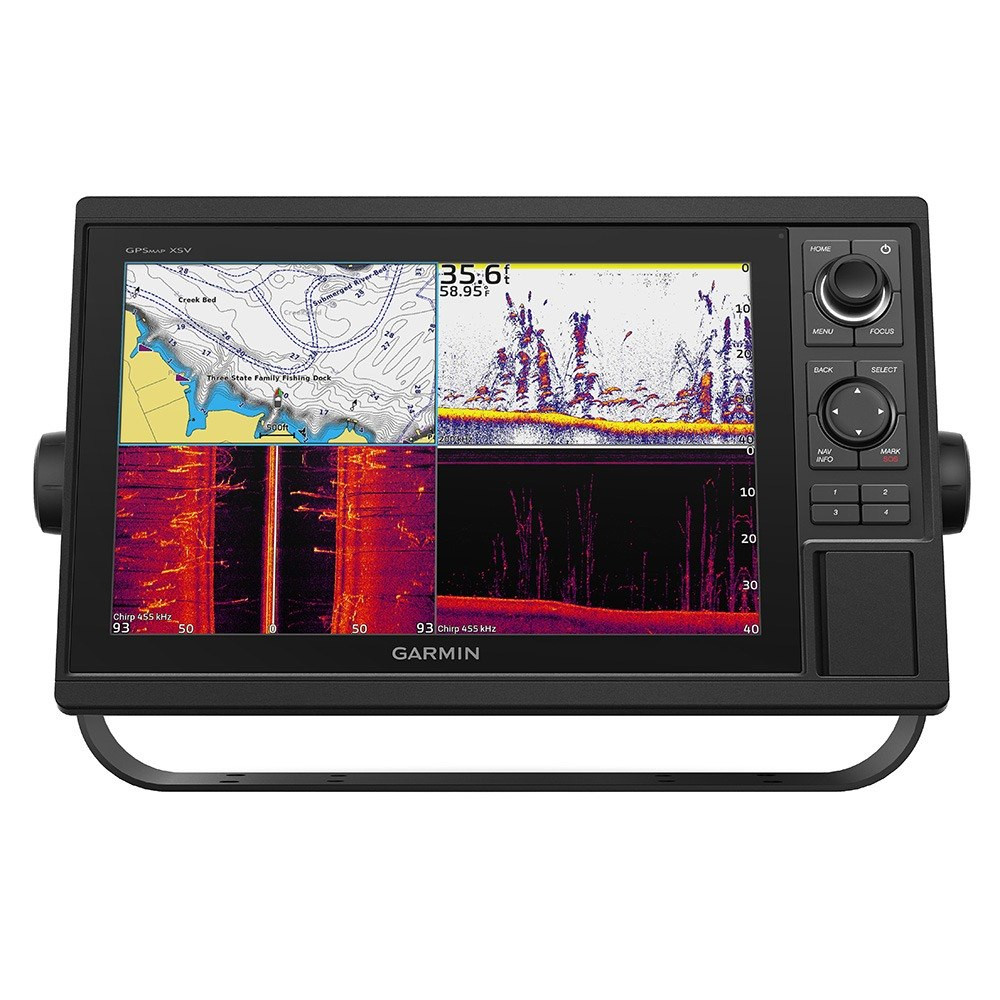
Navigate with confidence using the Garmin GPSMAP 1242xsv, a 12-inch chartplotter and sonar combo featuring a bright display and intuitive keypad controls. It includes a GT52-TM transducer for comprehensive Garmin CHIRP, ClearVü, and SideVü scanning sonars, plus support for advanced LiveScope technology. Preloaded with Garmin Navionics+ charts for coastal and inland waters, it offers Auto Guidance+ for planning. Built-in Wi-Fi connects to the ActiveCaptain app for smart features and data sharing. Network capabilities include NMEA 2000, NMEA 0183, and Ethernet for seamless integration with other marine electronics.
$2399.99
Owner Satisfaction
4.7
/ 5
Category Rank
3
/ 337
#3 in Marine Chartplotters & GPS
Price vs Category Average
+26%
Above average
Dimensions
14.18.92.735.822.66.9
/ " x " x " ( x x cm)
Who it's for
- Boaters seeking a complete, ready-to-use navigation and sonar package
- Captains needing clear, expansive views for complex data monitoring
- Anglers requiring high-definition underwater detail for precise fish targeting
Who should skip it
- Casual weekend boaters on a strict budget
- Users wanting to avoid ongoing monthly service fees
- DIY owners lacking advanced marine electronics installation experience
Performance breakdown
Sonar Versatility
Comprehensive scanning options provide unmatched underwater clarity for serious anglers.
Interface Tactility
Keypad controls offer reliable, precise operation in rough, wet marine conditions.
Network Integration
Seamlessly connects with existing marine electronics via NMEA and Ethernet protocols.
Display Visibility
Large 12-inch screen ensures critical navigation data remains legible under sunlight.
Mapping Capability
Preloaded charts and Auto Guidance+ make complex route planning effortless.
Smart Connectivity
ActiveCaptain app integration keeps software updated and data synced wirelessly.
Key Specs
Dimensions
14.1" x 8.9" x 2.7" (35.8 x 22.6 x 6.9 cm)
Display size
12.1 inches
Display resolution
1280 x 800 pixels
Weight
5.2 lbs (2.34 kg)
Waterproof rating
IPX7
Power consumption
Max 34.8 W at 10 Vdc
Waypoints capacity
5,000
Routes capacity
100
Features
- Large 12-inch keyed display for clear visibility
- Integrated CHIRP, ClearVü, and SideVü sonar
- Supports advanced LiveScope and Panoptix sonar
- Preloaded Garmin Navionics+ coastal and inland charts
- Wi-Fi connectivity for ActiveCaptain app integration
- Garmin Marine Network for data sharing
- Quickdraw Contours map creation software
- NMEA 2000 and NMEA 0183 network support
What customers say
Users overwhelmingly value this Garmin bundle for its exceptional reliability and professional grade performance. The brilliant 12-inch display offers superior clarity for charts and sonar interpretation. Key features like integrated ClearVü, SideVü, and traditional CHIRP sonar are praised for pinpoint accuracy in finding structure. The inclusion of satellite weather provides crucial, real time safety overlays for offshore trips. While initial setup can be complex, the system’s intuitive interface ensures seamless operation once running. Despite the high initial cost, customers agree the robust build quality and comprehensive feature set make this a worthwhile long term investment, delivering dependable results.
Know before you buy
The unit includes a GT52-TM transducer, which provides traditional CHIRP, ClearVü, and SideVü scanning sonar capabilities right out of the box.
Yes, the GPSMAP 1242xsv is fully compatible with LiveScope and Panoptix sonar systems, allowing you to add real-time, live-scanning sonar to your setup.
The keypad interface is designed for reliability in rough sea conditions where touchscreen precision can be difficult. It offers tactile, intuitive control that remains responsive even when your hands are wet or you are wearing gloves.
Yes, the device features full NMEA 2000 and NMEA 0183 support, making it easy to integrate with your existing marine electronics, such as autopilots, engine sensors, and AIS systems.
The Wi-Fi connection allows you to sync your device with the ActiveCaptain app on your smartphone. This enables smart notifications, easy software updates, and the ability to download map updates or upload your own Quickdraw Contours data to the community.
Yes, the unit features Quickdraw Contours software, which allows you to instantly create personalized HD fishing maps with 1-foot contours as you navigate the boat.

Still have a question?
Ask Hayley anything about this product before you decide.
Ready to buy?
$2400