GPSMAP 66sr
Best handheld navigator for serious backcountry explorers needing extreme location precision.

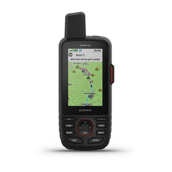
Navigate the great outdoors with confidence using the GPSMAP 66sr, a robust, button-operated handheld GPS designed for serious adventurers. Its multi-band GNSS technology delivers exceptional accuracy in challenging environments, complemented by a large, sunlight-readable color display. This device supports direct BirdsEye Satellite Imagery downloads and integrates seamlessly with the Garmin Explore platform. Built to MIL-STD-810G standards, it's ready for any expedition, offering essential navigation sensors and live Active Weather updates for informed journeys.
$509.00
Owner Satisfaction
4.5
/ 5
Category Rank
24
/ 125
#24 in GPS Navigation Systems
Price vs Category Average
+8%
Above average
Display Size
3.0
/ inches
Who it's for
- Backcountry explorers needing precise location tracking in dense terrain
- Multi-day hikers wanting reliable power without carrying extra batteries
- Outdoor adventurers requiring clear maps in bright, direct sunlight
Who should skip it
- Budget-conscious hikers seeking a basic navigation tool
- Ultralight backpackers prioritizing minimal pack weight
- Users accustomed to intuitive smartphone touchscreen interfaces
Performance breakdown
GNSS Accuracy
Multi-band technology maintains a precise lock in even the deepest canyons.
Durability
MIL-STD-810G construction survives the harshest drops and extreme environmental conditions.
Battery Longevity
Thirty-six hours of runtime keeps you powered through long-distance backcountry treks.
Display Visibility
Sunlight-readable screen remains perfectly legible under the brightest midday glare.
Ecosystem Integration
Seamlessly syncs with Garmin Explore for efficient trip planning and management.
Interface Usability
Tactile button controls offer reliable operation when wearing gloves or wet.
Key Specs
Display Size
3.0 inches
Display Resolution
240x400 pixels
Battery Life
36.0 hours
Internal Memory
16.0 GB
Expandable Memory Type
microSD
Water Resistance Rating
IPX7
Weight
230.0 grams
Sensors
Barometric Altimeter and 3-axis Electronic Compass
Features
- Superior multi-band GNSS accuracy
- Direct BirdsEye Satellite Imagery downloads
- Garmin Explore platform compatibility
- Rugged MIL-STD-810G rated design
- Live Active Weather updates
- Built-in navigation sensors
- Supports custom and preloaded maps
- Integrated Geocaching Live
What customers say
Users highly value the Garmin GPSMAP 66sr for its exceptional accuracy and rugged reliability, making it a favorite among serious outdoor enthusiasts. The multi-band GNSS technology delivers superior positioning even in difficult terrain. Its robust build quality inspires confidence for harsh conditions. While the premium price is noted, most agree the professional grade performance justifies the cost. Battery life consistently meets expectations for long trips. Although the interface has a slight learning curve, the overall sentiment strongly favors this device as an indispensable tool for those prioritizing top tier navigation performance and durability.
Know before you buy
Multi-band technology allows the device to access multiple frequencies from navigation satellites. This significantly improves position accuracy in challenging environments like deep canyons, dense forests, or areas with tall buildings where signals often bounce or get blocked.
No, the device supports direct-to-device downloads of BirdsEye Satellite Imagery without the need for an annual subscription. You can download these high-resolution images directly to the unit via Wi-Fi.
The GPSMAP 66sr is built to MIL-STD-810G standards, meaning it is tested for thermal, shock, and water resistance. It also carries an IPX7 water rating, so it can withstand accidental immersion in water up to one meter for 30 minutes.
Yes, the device features 16 GB of internal memory and includes a microSD card slot. This allows you to expand your storage for additional topographic, marine, or custom maps as needed.
When paired with the Garmin Explore app on your smartphone, the device provides real-time weather forecasts and live weather radar maps. This ensures you stay informed about changing conditions even when you are off the grid.
Yes, the 3-inch color display is specifically designed to be sunlight-readable. It maintains high visibility even in bright, outdoor conditions, ensuring you can check your route without struggling with glare.

Still have a question?
Ask Hayley anything about this product before you decide.
Ready to buy?
$509