GPSMAP 86sci
Best handheld navigator for offshore sailors needing reliable satellite communication.

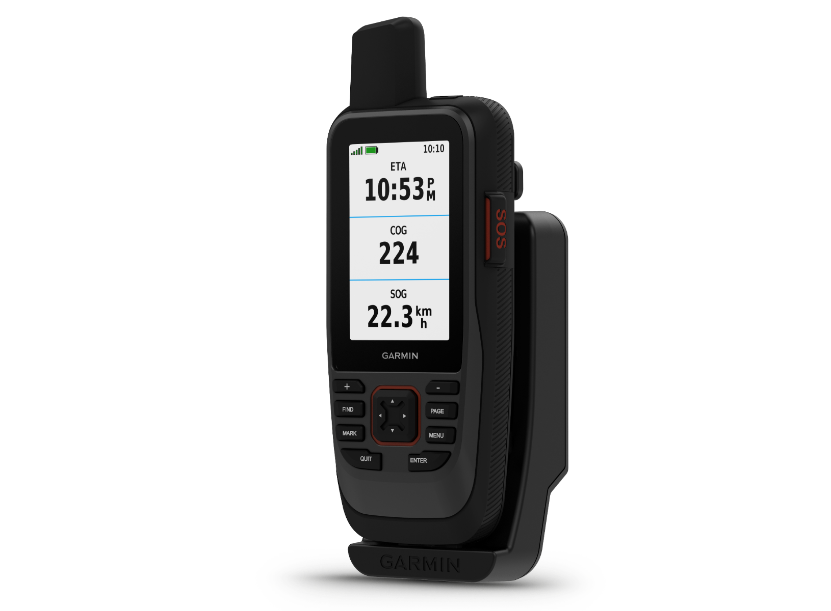
Navigate the waters with confidence using the Garmin GPSMAP 86sci. This rugged, floating handheld device is built for marine adventures, featuring a brilliant 3-inch sunlight-readable color display for clear visibility in any light. Integrated inReach technology provides two-way satellite messaging and SOS alerts, ensuring you stay connected offshore. Preloaded with detailed BlueChart g3 charts for U.S. and Canada, it offers comprehensive coastal and inland navigation. The device supports multiple satellite systems and includes essential sensors for accurate positioning and heading.
$449.99
Owner Satisfaction
4.6
/ 5
Category Rank
94
/ 238
#94 in Marine Chartplotters & GPS
Price vs Category Average
-76%
Below average
Display Size
3.0
/ inches
Who it's for
- Offshore sailors needing reliable emergency communication
- Boaters wanting immediate, high-detail navigation maps
- Adventurers working in harsh, bright marine environments
Who should skip it
- Budget-conscious buyers seeking a basic handheld GPS
- Users avoiding recurring monthly service costs
- Expedition travelers requiring multi-day battery endurance
Performance breakdown
Marine Navigation Precision
Multi-GNSS support ensures pinpoint accuracy even in challenging offshore conditions.
Satellite Connectivity
Integrated inReach technology provides reliable global messaging and emergency SOS capabilities.
Durability and Buoyancy
Rugged, floating design offers peace of mind during rough water excursions.
Display Visibility
Sunlight-readable screen maintains excellent clarity under harsh, direct marine glare.
Battery Endurance
Expedition mode delivers exceptional longevity for extended multi-day maritime adventures.
Mapping Versatility
Preloaded charts are comprehensive, with microSD expansion for custom map needs.
Key Specs
Display Size
3.0 inches
Display Resolution
240 x 400 pixels
Battery Life
Up to 35 hours (GPS mode), 200 hours (expedition mode)
Water Resistance Rating
IPX7
Weight
281 grams
Internal Storage
16 GB (expandable via microSD)
Satellite Systems
GPS, GLONASS, Galileo
Dimensions
6.7 cm x 4.2 cm x 17.8 cm
Features
- Two-way satellite messaging and SOS alerts
- Floats and is highly water-resistant
- Preloaded BlueChart g3 charts
- Sunlight-readable 3-inch color display
- Supports GPS, GLONASS, and Galileo
- Built-in altitude and heading sensors
- Wi-Fi, Bluetooth, and ANT+ connectivity
- Dedicated Garmin SailAssist features
What customers say
Serious mariners highly value the Garmin GPSMAP 86sci primarily for its integrated inReach satellite communication. Users find the two way messaging, SOS capabilities, and tracking features offer invaluable peace of mind when cellular service is absent. This focus on critical safety and communication is the device's core strength. Reviewers also consistently praise the robust build quality, water resistance, and excellent battery life, confirming its reliability in harsh marine settings. While the initial cost and subscription are noted, users agree the essential connectivity and navigation functions justify the investment. It is regarded as an indispensable tool for remote ventures.
Know before you buy
Yes, the device is designed to float. Its rugged, water-resistant construction ensures it stays buoyant if accidentally dropped in the water, making it ideal for marine environments.
Yes, an active satellite subscription is required to access the two-way messaging and SOS capabilities. You can choose from various service plans depending on how frequently you plan to use the device.
The device comes preloaded with BlueChart g3 maps specifically for the U.S. and Canada. If you are traveling outside these regions, you can purchase and download additional mapping via the microSD card slot.
In standard GPS mode, you can expect up to 35 hours of battery life. If you are on an extended trip, switching to expedition mode can extend the battery life up to 200 hours.
Yes, the GPSMAP 86sci supports Wi-Fi, Bluetooth, and ANT+ connectivity. This allows it to sync with compatible Garmin marine chartplotters and instruments to act as a remote display or controller.
The 3-inch color display is specifically designed to be sunlight-readable. It maintains high visibility and contrast even in bright, glare-heavy marine conditions.

Still have a question?
Ask Hayley anything about this product before you decide.